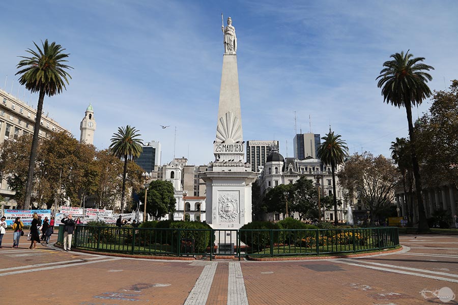
- Pirámide de Mayo in the center of Plaza de Mayo in central Buenos Aires.
As rich in colonial architecture as it is in cultural diversity, the great city of Buenos Aires is one of the most beautiful cities in all of South America. With ornate buildings, expansive plazas, and peaceful parks, the city has an almost calm and relaxed atmosphere, despite being home to over 13 million people. Since my time in South America is nearly at an end, I made a quick weekend trip to see this iconic city while I still could. I was impressed by the gorgeous architecture, cleanliness, organized layout, and smooth blend of modern infrastructure with historic buildings. I'm grateful to have had the opportunity to experience it before leaving the continent.
MAY 1, 2015
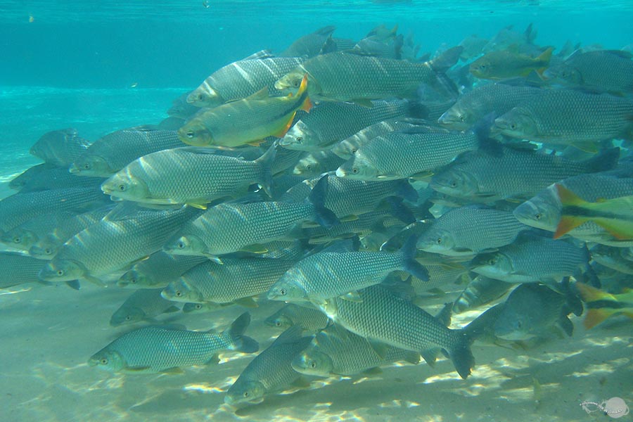
- The crystal clear rivers of Bonito are teeming with marine life.
Located south of The Pantanal, Bonito is a small town in the state of Mato Grosso do Sul. In the countryside around the city, underground springs feed clear rivers that hold an incredible blue color and contain some of the world’s most beautiful aquatic environments. This, combined with the green forested landscape full of wild animals, has made Bonito a popular tourist destination. I spent a long weekend here swimming under waterfalls, snorkeling in the clear rivers, and observing macaws, toucans, and monkeys in the forest.
APRIL 4, 2015
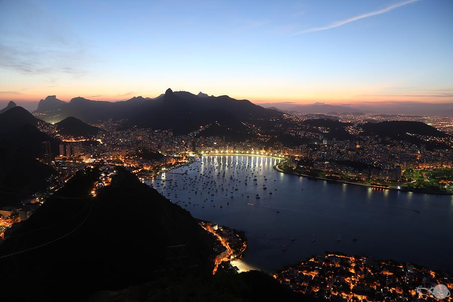
- Sunset view from the top of Sugarloaf.
My friend and coworker, Mark, and I returned to Rio de Janeiro to enjoy the sites of the city one last time. We went up on Sugarloaf, took a helicopter ride over the city, and spent a day relaxing on Copacabana beach. The weather was great and we enjoyed an awesome weekend.
MARCH 6, 2015
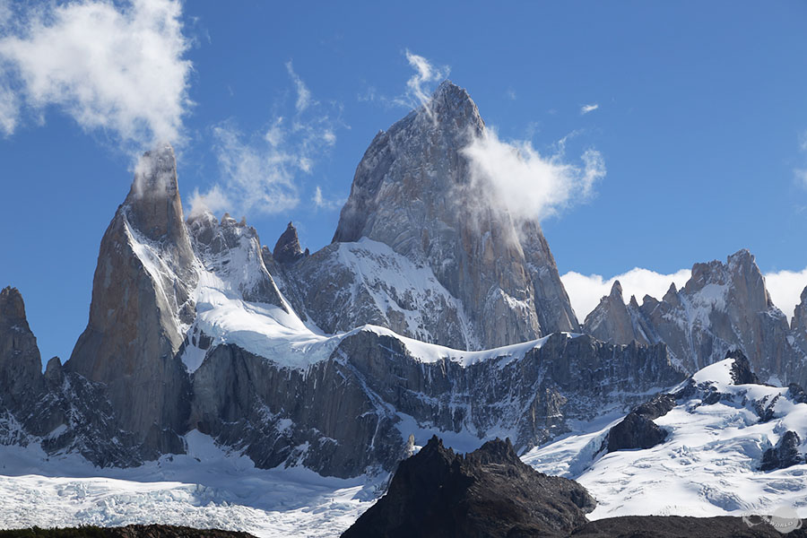
- The magnificient Mt. Fitz Roy is one of the icons of Patagonia.
Possibly the most impressive mountain in Patagonia, the towers of Mount Fitz Roy jut vertically out of the Patagonian Ice Field on the Chile-Argentina border. With 6,400 feet of prominence, the mountain stands dominant in a chain of other, less obtrusive, glacier capped mountains, which define Patagonia's rugged landscape. Located inside the upper corner of Los Glaciares National Park, well maintained trails provide access from the small town of El Chalten to Laguna de los Tres at the base of Mount Fitz Roy. In two days of hiking in this area, I was fortunate to have some clear views of this incredible landscape before the quickly changing weather obscured the peaks in clouds.
MARCH 5, 2015
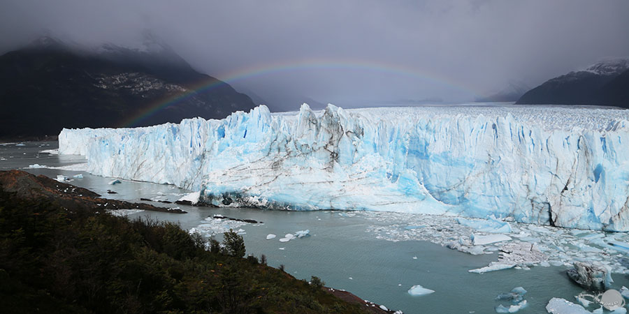
- A rainbow over the stunning Perito Moreno Glacier.
Extensive, flowing glaciers are one the most defining and awe-inspiring characteristics of Patagonia. One of many glaciers fed by the Southern Patagonian Ice Field, the Perito Moreno glacier in Argentina's Los Glaciares National Park is 19 miles long and over 3 miles wide at its terminus in Argentino Lake. This amazing field of compressed ice pops and groans as it slowly advances, and occassionally large chunks of ice split from the leading edge and collapse into the the lake. At first I was disappointed by the cold, rainy weather, but for a few moments, the clouds shifted, allowing a beautiful rainbow to appear over the glacier.
FEBRUARY 27, 2015
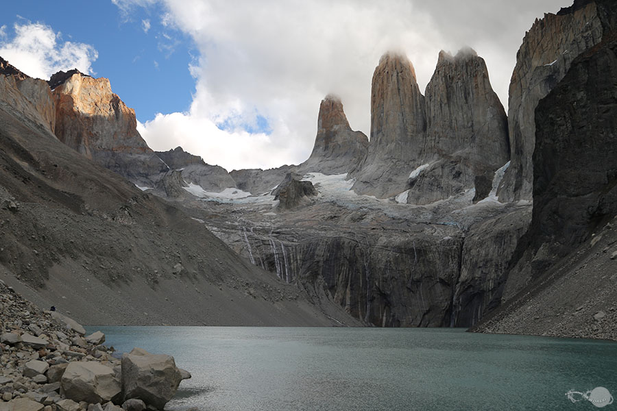
- The towers of Torres del Paine reach to the clouds.
A region of rugged granite peaks, massive glaciers, turquoise lakes, and volatile weather, southern Patagonia contains some of the most stunning scenery in South America. Torres del Paine National Park, located in the south of Chile, provides the best access into the Patagonian Mountains with a substantial network of trails extending into the park. I spent four days here hiking the W route and, even though I only got to see a few of the park's iconic features before bad weather moved in, it was a unique and rewarding experience.
FEBRUARY 24, 2015
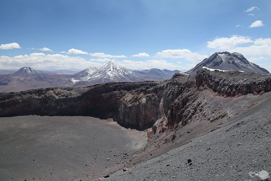
- The Aguas Calientes, Acamarachi, and Chiliques volcanos viewed from the top of Lascar volcano.
One of the most active volcanos in the Chilean Andes, the Lascar volcano sits in a line of volcanic peaks, several hours south of San Pedro de Atacama. Though the mountain's peak has been blown away by past eruptions, the highest point of the crater rim still reaches to an impressive 18,300 ft above sea-level. The climb to the top was strenuous due to the lack of oxygen in the air, but the views over the high Andean peaks and the experience of peering into the active crater were well worth the effort.
FEBRUARY 23, 2015
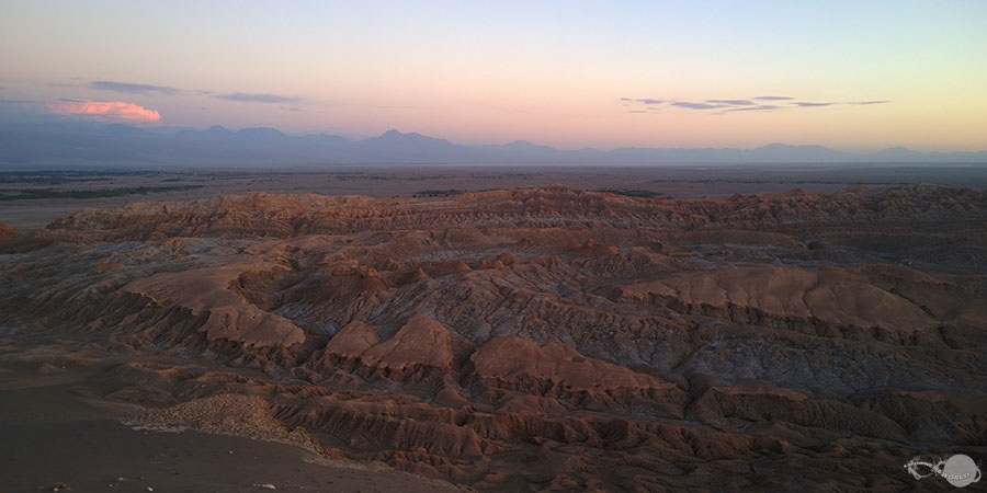
- Valley of the Moon and the Atacama Desert at dusk.
Located on the western side of the Andes, the Atacama Desert is the driest desert in the world, with some areas having no records of rainfall. However, despite the arid conditions, the desert still contains lagoons, small wetlands, and geysers fed by underground water sources. Additionally, unique features such as the Valley of the Moon, near the town of San Pedro de Atacama, create alluring landscapes that draw visitors from all over the world.
FEBRUARY 19, 2015
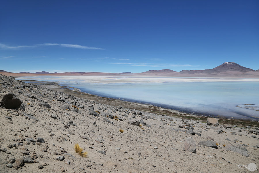
- A light blue lagoon on the expansive Bolivian Altiplano.
The Altiplano, most of which lies in Bolivia, is a high-altitude plateau in the Andes mountain range. It's characterized by salt flats, lagoons, geysers, snowcapped mountains, flamingos, llamas, and vicunas. With an average elevation of over 12,000 ft, the clear skies hold a pristine blue color during the day and provide incredible views of the Milky Way at night. The striking mix of colors in this unique region were captivating and as a photographer, it was a visual paradise.
FEBRUARY 17, 2015
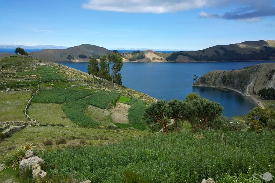
- The hillsides of Isla del Sol near the small town of Yumani.
Isla del Sol, or Island of the Sun, is the largest island on Lake Titicaca. The island was considered sacred in the Inca religion and said to be the birth place of the sun. Only accessible by boat, the island has a calm and peaceful environment, dotted with small farming villages and Incan archeological remains. On a clear day, the view from the high points of the Island is stunning as the deep blue expanse of Lake Titicaca contrasts beautifully with the bright green slopes of the island and the snowcapped Andean peak on the eastern horizon.
FEBRUARY 16, 2015
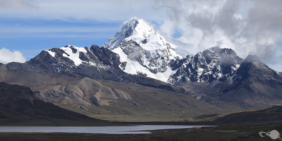
- Huayna Potosi mountain viewed from the route to Chacaltaya mountain.
Chacaltaya is one of the most easily accessible mountain peaks near La Paz. The peak is at 17,785 ft above sea-level and offers amazing views of the Cordillera Real mountains (a subrange of the Andes) and the neighboring Huayna Potosi mountain, reaching up to 19,974 ft above sea-level. A narrow mountain road provides access all the way up to within 330 feet of the summit of Chacaltaya, where a small visitor center is the starting point for the short hike to the summit.
FEBRUARY 7, 2015
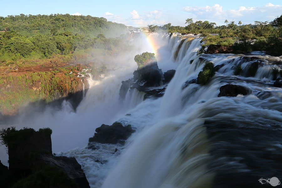
- Overlooking a small section of Iguazu Falls in the late afternoon.
Located on the border between Brazil and Argentina, the magnificent Iguazu Falls are one of South America's most spectacular natural wonders. Comprised of hundreds of individual falls that pour over the edge of a 1.7 mile wide shelf, Iguazu Falls is among the largest waterfalls in the world, based on width and volume. The national parks on each side of the river extend to protect a large tract of the subtropical Atlantic Forest, which contains thousands of plant species and is home to toucans, howler monkeys, caimans, tapirs, ocelots, and jaguars. This was my second trip to Iguazu Falls and I was happy to have two days of excellent weather to make up for the cold, rainy days I experienced on my first trip in 2013.
JANUARY 22, 2015
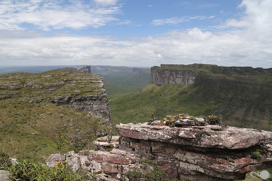
- Looking over the Chapada Diamantina National Park from the top of Morro do Pai Inacio.
Chapada Diamantina, or the Diamond Highlands, is a national park located west of Salvador in the state of Bahia, Brazil. It's a region of scrublands with high plateaus, shear cliffs, small rivers, and underground cave networks. Throughout the park there are many beautiful waterfalls, pristine underground pools, and a wide variety of plant and animal life. I was able to carve out two and a half days to spend exploring this unique region and I came away with a fun experience and an array of images that portay yet another of Brazil's diverse landscapes.
DECEMBER 26, 2014
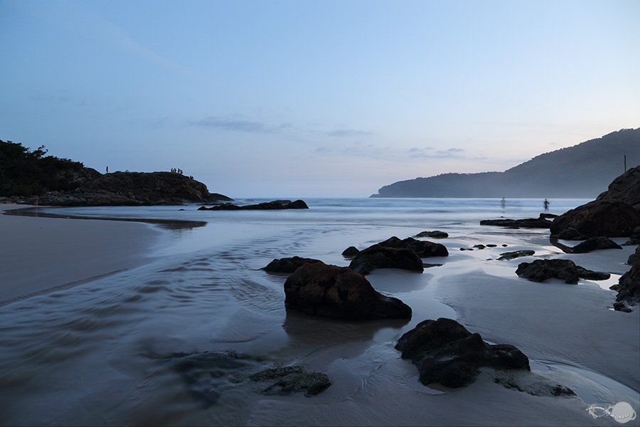
- A peaceful evening setting on Praia do Cachadaco near the small coastal town of Trindade.
To end the 2014 year, I had the opportunity to travel with my parents along the beautiful Brazilian coast from Ilhabela Island to Rio de Janeiro. We had excellent weather and enjoyed relaxing on some of Brazil's most beautiful beaches. There were many tranquil moments along the way, such as this evening scene on the beach near Trindade. At the conclusion of the trip, we brought in the new year with the impressive fireworks displays in Rio.
SEPTEMBER 21, 2014
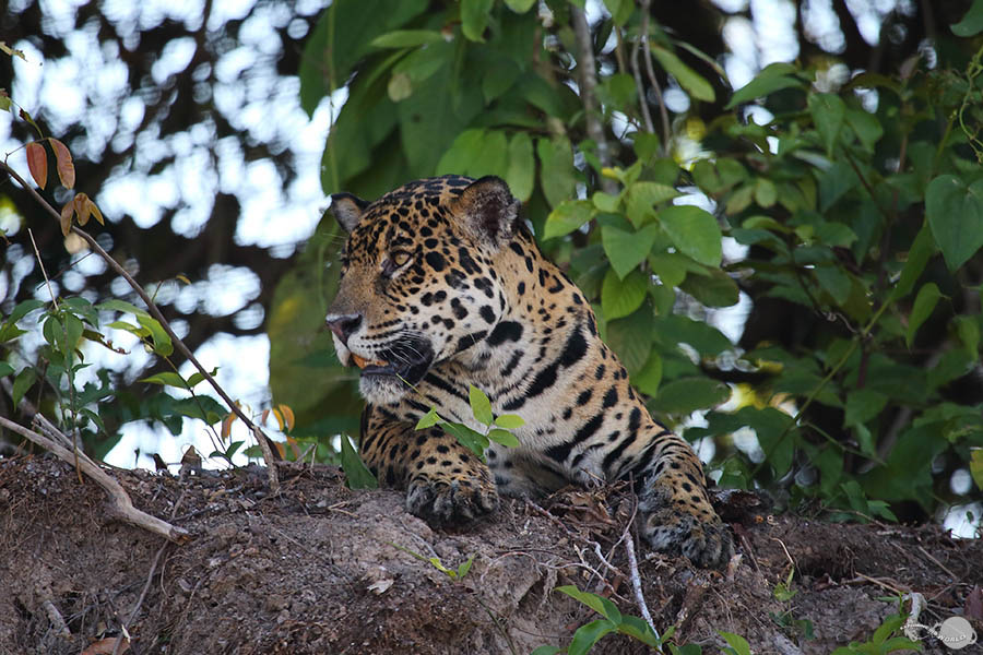
- In Brazil's Pantanal, a jaguar relaxes in the shade of the forest on the river bank.
The Pantanal, located in the Brazilian states of Mato Grosso and Mato Grosso do Sul, is the world's largest inland swamp. It holds an amazing concentration of wildlife, including several endangered species such as the hyacinth macaws, and it's one of the few places you can still see jaguars in the wild. Spending four days here has been one of my favorite experiences in Brazil. There was never a moment without wildlife around me and each day concluded with a beautiful pantanal sunset.